| NASA | GSFC | JPL | Site Map |
|
||
 |
 |
Student Outcomes: Online Tools |
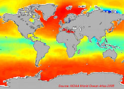
Annual Cycle of Monthly Mean Data
K-4: Ocean Circulation Describe the connections between the salt water found in the ocean and the fresh water in the water cycle. 2a. How does large-scale atmospheric circulation influence global patterns on land and sea?
2c. How does large-scale atmospheric circulation influence sea surface salinity patterns? (Q&A #2 pdf)
3a. What is the contribution of fresh water from rivers to the oceans?
3b. To what extent do rivers impact the salinity of the oceans? (Q&A #3 pdf) Note: Q&As can be used as demonstrations by teachers but are not designed for direct K-4 student use. Videos: Global precipitation | Atmospheric water vapor | Global rivers Explain the effect of density on ocean circulation. New "Q&A": How do ocean densities vary between winter and summer? How do they change from the surface to 300m depth? STEP 1: Compare Winter & Summer Densities at the Ocean Surface Click on the Annual Cycle tool.
Above "Interactive Map", click on the "Density" radio button.
Below the map, use the pull-down menu labeled "Month" to change the month from "Jan" through "Jul". NOTE: The "Data Source" pull-down menu should be "Atlas" and "Depth (m)" should be "0".
What is the difference between these maps? STEP 2: Compare Winter & Summer Densities at 300 Meters Depth As in Step 1, the "Temperature" radio button should be clicked above the "Interactive Map".
Below the map, use the pull-down menu labeled "Depth (m)" to change the depth from the surface (0 m) to "300".
As in Step 1, use the pull-down menu labeled "Month" to change the month from "Jan" through "Jul".
What is the difference between these maps? STEP 3: Analysis Cooling of the ocean makes the ocean denser; evaporation makes the ocean saltier and hence denser. On the other hand,
warming of the ocean makes it less dense; precipitation also makes it less dense. Ocean water moves to a depth where its
density matches that of the surrounding ocean. Based on observations in Step 1 (sea surface) and Step 2 (300 m depth), which
depth is likely to have more movement of water? Watch the videos Thermohaline Circulation and Salt of the Earth (Parts 1 and 2) to learn more about the nature of deep ocean circulation. Explain the effect of solar energy heat on ocean circulation. New "Q&A": How do ocean temperatures vary between winter and summer? How do they change from the surface to 300m depth? STEP 1: Compare Winter & Summer Temperatures at the Ocean Surface Click on the Annual Cycle tool.
Above "Interactive Map", click on the "Temperature" radio button.
Below the map, use the pull-down menu labeled "Month" to change the month from "Jan" through "Jul". NOTE: The "Data Source" pull-down menu should be "Atlas" and "Depth (m)" should be "0").
What is the difference between these maps? STEP 2: Compare Winter & Summer Temperatures at 300 Meters Depth As in Step 1, the "Temperature" radio button should be clicked above the "Interactive Map".
Below the map, use the pull-down menu labeled "Depth (m)" to change the depth from the surface (0 m) to "300".
As in Step 1, use the pull-down menu labeled "Month" to change the month from "Jan" through "Jul".
What is the difference between these maps? STEP 3: Analysis Based on the seasonal temperature differences observed in Step 1 (sea surface) and Step 2 (300 m depth), what can you conclude about
the affect of solar energy heat on ocean circulation? Applicable Videos: Gather, analyze, and interpret environmental data about the ocean's effects on climate. Look at the "Q&A" section for ideas on how this tool could be used to meet this student outcome. Explain the relationship between fresh water and ocean dynamics. 4a. What are the main causes for SSS annual cycle?
4b. Which regions have marked seasonal variability in SSS?
4c. Which regions of the ocean have SSS variability mainly caused by evaporation/precipitation?
4d. Which regions have SSS variability mainly caused by river runoff?
4f. What other factors affect SSS variability? (Q&A #4 pdf) Applicable Videos: Explain the influence of ocean salinity on the thermohaline circulation (e.g., "global conveyor belt"). Look at the "Q&A" section for ideas on how this tool could be used to meet this student outcome. Conduct a complex experiment to answer a question they have about the effect of ocean salinity on climate. Look at the "Q&A" section for ideas on how this tool could be used to meet this student outcome. | |||||||||||||||||||||||||||||||||||