| NASA | GSFC | JPL | Site Map |
|
||
 |
 |
Education: Student Outcomes |
Filtered by grade level: K-4 Click here to begin a new search | |||||
Grade levels: K-4, 5-8, 9-12 Themes: 21st century technology, ocean circulation, water cycle Flat Tool: http://ourocean.jpl.nasa.gov/AQUARIUS/chp2.jsp GoogleEarth Interface Tool: http://aquarius.jpl.nasa.gov/AQUARIUS_DEV/chp2.jsp Create global maps of mean conditions for any month at designated depths (down to 1500m) using the pull-down menus. Monthly time-series graphs of salinity, temperature, or density can be plotted by selecting up to six locations (by clicking on the map or typing latitude/latitude information into the fields below). These time-series graphs can also represent up to six different depths. Plotted data will also be shown in a table that is easily downloaded (e.g., into Excel). Sources include interpolated atlas data or actual measurements from the database. Focus Questions | Flat Tool Tutorial | |||||
Grade level: K-4 Theme: water cycle Activity: http://aquarius.nasa.gov/sea_water_freeze.html Big Idea Salt causes water to freeze at a lower temperature. The oceans do not freeze (except in extreme polar areas) because of the salinity (i.e., concentration of salts).
Key Concepts Dissolving any substance in pure water raises or lowers the freezing and boiling point.
When water freezes - goes from the liquid state to the solid state - its molecules go from a disorganized state to an organized state.
When water freezes to a solid, molecular motion slows down enough that the molecules become permanently fixed in an orderly arrangement called a crystal.
The individual particles that make up salt (known as ions) arrange themselves around the water molecules. In doing so, they shield the water molecules from interactions among themselves, making it less likely that they will find each other and form ice.
The water molecules have to be slowed down even more in the presence of salt in order to form a solid. So you have to go to a lower temperature in order to freeze water that contains salt.Salt is excluded in the formation of ice; therefore ice made from salt water is essentially salt-free.
Salt water is denser than freshwater because of its salt content, and, as a result, an object is more buoyant in the ocean than in a freshwater lake. The density of salt water depends on its salinity and varies around the world. Background Under normal conditions, ordinary fresh water freezes and melts at 0°C, or 32°F. If water and ice are at 0°C, which is the melting point of ice and the freezing point of water then molecules of ice are escaping into the water (melting), and molecules of water are being captured on the surface of the ice (freezing). (more) | |||||
Grade levels: K-4, 9-12 Theme: 21st century technology Video: global_ocean_01.flv
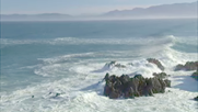
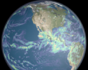
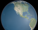
Paula Bontempi: "You can see the atmosphere, you can see the land, but you can't really see beneath the ocean's surface. So you start wondering, you know, what's going on beneath the part we can see." David Adamec: "We walk in a very small part of the atmosphere, and we walk on the land. And it's how that interaction takes place with the ocean, the atmosphere, and the land that determines our quality of life. Our goal is to understand the interconnectedness of it all." For years, people have worked to unravel the mysteries of the oceans. Scientists gather data from ships and buoys on the surface, take the plunge to explore ocean depths, and fly overhead to get a bigger picture. But one of the best views of oceans might be from way, way overhead. It's the view from space. Paula Bontempi: "The one thing that NASA satellites do that nothing else does, ships or buoys or anything else, is actually give you a picture of the globe within a few days. You get a much broader view of what's going on in some part of the Earth's system, and you can link that together to understand the Earth as a whole." | |||||
Grade level: K-4 Theme: climate Activity: http://www.nationalgeographic.com/xpeditions/lessons/01/g35/tgcontinents.html Consider distance from an ocean in this lesson where students examine a map and globe for comparison of the physical features of Earth's continents. Students will play the GeoSpy continents game and manipulate an online map, then write paragraphs comparing and contrasting two continents. The idea for this lesson plan was inspired by Suzie Howell-Olsen and Katie Hansen of Meadow School in Petaluma, California, who received a teacher grant from the National Geographic Education Foundation in support of a year-long project called A Survey of the Continents. | |||||
Grade level: K-4 Theme: 21st century technology Design your own experiment based on the activities conducted for the following outcomes:
| |||||
Grade level: K-4 Theme: water cycle Activity: http://aquarius.nasa.gov/evap_invest.html Big Idea Water can "disappear" or evaporate into the air.
Key Concepts Evaporation occurs when a liquid is changed into a gas.
Rate of evaporation increases when the temperature of a liquid is increased.
Water moves around our planet in the water cycle.
Background Evaporation is the process by which water changes from a liquid to a gas or vapor. Evaporation is the primary pathway that water moves from the liquid state back into the water cycle as atmospheric water vapor. Studies have shown that the oceans, seas, lakes, and rivers provide nearly 90 percent of the moisture in the atmosphere via evaporation, with the remaining 10 percent being contributed by plant transpiration. | |||||
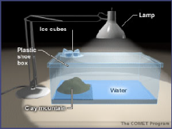
Grade level: K-4 Theme: water cycle Video: salty_regions.flv
And also in the middle of our subtropical gyres. A gyre is a current system that moves around in a circle. The "subtropics" means that it is located in an area around 30 degrees (north) latitude all around the globe. That area is where we have very strong evaporation. That evaporation means that we lose fresh water from the surface. And we lose more fresh water from the surface than we actually gain through precipitation. That area is what we call "the ocean deserts". Now on the fresh side, we have very fresh water near the coastlines and that's because we have the river waters flowing in. And we also have fresh water near the high latitudes where we have ice. | |||||
Grade level: K-4 Theme: climate Tool: http://blueplanetbiomes.org/climate.htm
Climate is the characteristic condition of the atmosphere near the earth's surface at a certain place on earth. It is the long-term weather of that area (at least 30 years). This includes the region's general pattern of weather conditions, seasons and weather extremes like hurricanes, droughts, or rainy periods. World biomes are controlled by climate. The climate of a region will determine what plants will grow there, and what animals will inhabit it. All three components, climate, plants and animals are interwoven to create the fabric of a biome. Compare land biomes in this tool with ocean biomes. | |||||
Grade level: K-4 Theme: water cycle Activity: http://aquarius.nasa.gov/liquid_rainbow.html Big Idea When solutions of two different densities meet, the lower density (less dense) solution will move on top of the higher density (more dense) solution, resulting in a layering or stratification of the solutions. Density is an important feature of seawater since many physical and biological processes are affected by it, such as moving heat around the globe influencing climate and feeding and reproduction by marine organisms. Key Concepts Different densities of water, or solutions, will stratify to form layers.
Density of ocean water is influenced by temperature and salinity.
Cold water with dissolved salts (higher salinity) is denser than warm water without dissolved salts (low or no salinity).
In the oceans, the deep, bottom layer is colder and saltier than the surface layer.
Background Density is a property of matter that can be introduced at the elementary level by thinking of it in terms of the relationship between weight and volume. How can two objects that are the same size have different weights? The answer has to do with their density. An object's density is determined by comparing its mass to its volume. If you compare a rock and a cork that are the same size (they have equal volume), which is heavier? The rock is, because it has more mass. Thus the rock is denser than the cork because it has more mass in the same volume. | |||||
Grade level: K-4 Theme: climate Tool: http://www.windows.ucar.edu/tour/link=/earth/Water/marine_ecology.html
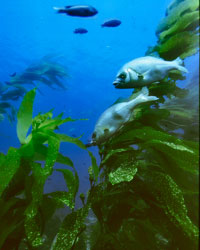
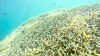
Life in the ocean is diverse. The smallest creatures that call the ocean home are so tiny that they can only be seen with a microscope. The largest creatures are blue whales, which can be as much as 34 meters (110 feet) long. There are many different ways to live in the ocean, too. Some animals travel huge distances through ocean water. Others stay in the same place on the ocean floor their entire lives. Some burrow beneath the sand while others float near the surface. The ocean is not the same everywhere. There are many different ecosystems within the ocean depending on conditions such as the water temperature, the amount of sunlight that filters through the water, and the amount of nutrients. Sunlight breaks through the top layer of ocean water. It can make its way as deep as 200 meters (656 feet). Almost all marine life (about 90 percent) lives within this top, sunlit layer of the ocean. There, phytoplankton, algae, and plants like seagrass make their own food through the process of photosynthesis and are the start of most marine food chains. The temperature of ocean water varies depending on its location. Water near the polar regions is colder than water near the equator. Water that is deep in the ocean is colder than water that is near the ocean surface. Many animals and other organisms can only survive at certain temperatures. Others are able to survive at a range of temperatures and can live in more places in the ocean. Compare ocean biomes in this tool with land biomes. | |||||
Grade level: K-4 Theme: water cycle Activity: http://aquarius.nasa.gov/prop_fresh_sea.html Big Idea Water has unique properties. About 97 percent of all water is in the oceans. Salt water or seawater has characteristics similar to fresh water with some noticeable differences because of the salts that are dissolved in water.
Key Concepts Life on Earth is possible because of water's unique properties.
Water is the only natural substance that is found in all three states -- liquid, solid (ice), and gas (steam) -- at the temperatures normally found on Earth.
Water can absorb a tremendous amount of heat acting like a heat buffer for the Earth.
Background Liquid water (H2O) is often perceived to be pretty ordinary as it is transparent, odorless, tasteless and ubiquitous. Water is unique in that it is the only natural substance that is found in all three states -- liquid, solid (ice), and gas (steam) - at the temperatures normally found on Earth. Earth's water is constantly interacting, changing, and in movement. Water freezes at 32° Fahrenheit (F) and boils at 212° F (at sea level). In fact, water's freezing and boiling points are the baseline with which temperature is measured: 0° on the Celsius scale is water's freezing point, and 100° is water's boiling point. Water is unusual in that the solid form, ice, is less dense than the liquid form, which is why ice floats. | |||||
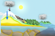
Grade levels: K-4, 5-8, 9-12 Themes: ocean circulation, water cycle Video: water_cycle_ipod_640x480.m4v.flv
Clouds can move great distances and eventually the water molecule will fall as rain or snow. Ultimately, the water molecule arrives back where it started...at the ocean. (source) | |||||
Grade level: K-4 Theme: ocean circulation Activity: http://aquarius.nasa.gov/water_cycle.html
Water can change states among liquid, vapor (gas), and ice (solid) at various stages of the water cycle. Temperature affects the change of water from one state to another. When water vapor gets cold it changes to a liquid. This is called condensation. When heat is applied to water, it changes from a liquid to a gas. This is called evaporation. This activity will focus specifically on two aspects of the water cycle: evaporation and condensation. Key Concepts Evaporation occurs when a liquid is changed into a gas.
Evaporation occurs when the temperature of a liquid is increased.
Condensation occurs when a gas is changed into a liquid.
Condensation occurs when the temperature of the vapor decreases.
When the sun heats up water in rivers, lakes or the ocean, it turns into vapor or steam. The water vapor or steam leaves the body of water and goes into the air. Background The water cycle has no starting point. But we'll begin in the oceans, since that is where most of the Earth's water exists. The sun, which drives the water cycle, heats water in the oceans. Some of it evaporates as vapor into the air. Ice and snow can sublimate directly into water vapor. Rising air currents take the vapor up into the atmosphere, along with water from evapotranspiration, which is water transpired from plants and evaporated from the soil. The vapor rises into the air where cooler temperatures causes it to condese into clouds. | |||||
Grade levels: K-4, 9-12 Themes: ocean circulation, water cycle Video: water_everywhere_02.flv
Condensation is the process by which water vapor molecules cool, stick together, and become liquid again in cloud formation. This often happens high in the atmosphere where the temperature is much lower than it is near the surface. Paula Bontempi: "What happens in the atmosphere is, just like we have currents in the ocean, we have winds in the atmosphere that actually, to some extent, drive what goes on in the ocean currents. Materials in the atmosphere can travel a great distance, sometimes a quarter of a way around the world, just until they get to the point where they actually turn into rain or snow and thereby fall back to the ocean or fall back to the land. This is called precipitation. If the water molecule falls on the land as snow, it may be stored for a very long period of time in a polar ice sheet or mountain glacier, depending on climate conditions." Matt Rodell: "When rain falls or the snow melts, typically the next place it goes, it infiltrates the soil. So soil is not solid. It's not like a rock, there are pore spaces that can be filled with water and typically there is a certain amount of water in the soil at all times. If soil was completely dry, plants wouldn't be able to grow." (source) | |||||
Grade levels: K-4, 9-12 Themes: ocean circulation, water cycle Video: WC_precipitation_IPOD.m4v.flv
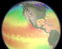
Water regulates climate, storing heat during the day and releasing it at night. Water in the ocean and atmosphere carry heat from the tropics to the poles. The process by which water moves around the earth, from the ocean, to the atmosphere, to the land and back to the ocean is called the water cycle. This animation was created using data from the GEOS-5 atmospheric model on the cubed-sphere, run at 14-km global resolution for 30-days. Variables animated here include evaporation, water vapor and precipitation. This animation is time synchronous throughout the animation to allow cross fades during compositing. (source) | |||||
Grade levels: K-4, 5-8, 9-12 Themes: ocean circulation, water cycle Video: water_everywhere_01.flv
Let's follow a single molecule of water, beginning in the ocean, through the paths it might take before eventually winding up right where it started - back in the big blue sea. The fuel for this journey will be provided by our planet's prime energy source: the sun. During the day, the sun heats up the air and ocean surface, causing water molecules to evaporate. Evaporation occurs when a liquid molecule of water escapes into the air as a gas. This scientific visualization shows how water evaporation, indicated in turquoise, is driven by the energy of the sun. Notice how the rate of evaporation pulses over land: it speeds up during the day and almost disappears at night. Over the ocean, evaporation appears to remain constant, both day and night. Water in the air in gas form is known as water vapor. The molecule is now fresh water, having left the ocean salt and other particles behind. (source) | |||||
Grade levels: K-4, 5-8, 9-12 Themes: ocean circulation, water cycle Video: Evap_and_clock_IPOD.m4v.flv
Water regulates climate, storing heat during the day and releasing it at night. Water in the ocean and atmosphere carry heat from the tropics to the poles. The process by which water moves around the earth, from the ocean, to the atmosphere, to the land and back to the ocean is called the water cycle. This animation was created using data from the GEOS-5 atmospheric model on the cubed-sphere, run at 14-km global resolution for 30-days. Variables animated here include evaporation, water vapor and precipitation. This animation is time synchronous throughout the animation to allow cross fades during compositing. (source) | |||||
Grade levels: K-4, 5-8, 9-12 Themes: ocean circulation, water cycle Video: WC_evaporation_IPOD.m4v.flv
Water regulates climate, storing heat during the day and releasing it at night. Water in the ocean and atmosphere carry heat from the tropics to the poles. The process by which water moves around the earth, from the ocean, to the atmosphere, to the land and back to the ocean is called the water cycle. This animation was created using data from the GEOS-5 atmospheric model on the cubed-sphere, run at 14-km global resolution for 30-days. Variables animated here include evaporation, water vapor and precipitation. This animation is time synchronous throughout the animation to allow cross fades during compositing. (source) | |||||
Grade levels: K-4, 5-8, 9-12 Themes: ocean circulation, water cycle Video: WC_vapor_IPOD.m4v.flv
Water regulates climate, storing heat during the day and releasing it at night. Water in the ocean and atmosphere carry heat from the tropics to the poles. The process by which water moves around the earth, from the ocean, to the atmosphere, to the land and back to the ocean is called the water cycle. This animation was created using data from the GEOS-5 atmospheric model on the cubed-sphere, run at 14-km global resolution for 30-days. Variables animated here include evaporation, water vapor and precipitation. This animation is time synchronous throughout the animation to allow cross fades during compositing. (source) | |||||
Grade levels: K-4, 5-8, 9-12 Themes: ocean circulation, water cycle Video: WC_SST_IPOD.m4v.flv
Water regulates climate, storing heat during the day and releasing it at night. Water in the ocean and atmosphere carry heat from the tropics to the poles. The process by which water moves around the earth, from the ocean, to the atmosphere, to the land and back to the ocean is called the water cycle. Data for this animation was derived from a model run of ECCO's Ocean General Circulation Model of heat along the ocean's surface. (source) | |||||
Grade levels: K-4, 5-8, 9-12 Themes: ocean circulation, water cycle Video: WC_rivers_IPOD.m4v.flv
Water regulates climate, storing heat during the day and releasing it at night. Water in the ocean and atmosphere carry heat from the tropics to the poles. The process by which water moves around the earth, from the ocean, to the atmosphere, to the land and back to the ocean is called the water cycle. (source) | |||||
Grade level: K-4 Theme: 21st century technology Video: http://ksnn.larc.nasa.gov/videos_cap.cfm?unit=studyspace
Some objects are too large to study well from the surface of the Earth. Again, hurricanes are a good example and so are earthquakes. Cracks in the Earth's crust, called faults, can cause earthquakes. Faults can be hundreds of miles long. Only satellites can see the entire fault at one time. Scientists and researchers around the world use NASA satellites. NASA's Earth Science Enterprise (ESE) and Earth Observing System (EOS) can study many natural hazards from space that can never be safely studied up close on Earth, such as fires, floods, storms, and volcanoes. Special instruments on these satellites can study hazards such as hurricanes in ways scientists can never study them on Earth. One satellite, called TRMM (Tropical Rainfall Measuring Mission), can "see" inside a hurricane. TRMM can tell that certain parts of hurricanes normally produce more rain. This information helps meteorologists forecast how much rainfall will affect people on the coast when hurricanes strike. Someday, this research may even help scientists forecast exactly where a hurricane will move onto land. Satellites allow scientists to observe remote parts of Earth that may be impossible to see except from space. Loss of trees in rainforests, the size of mountain glaciers and changes in our ozone layer can be measured best from space. | |||||