| NASA | GSFC | JPL | Site Map |
|
||
 |
 |
Education: Student Outcomes |
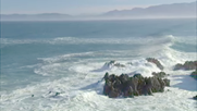
Click here to search for other assets Climate Change and the Global Ocean: Viewing Ocean Change by Satellite Grade levels: K-4, 9-12 Theme: 21st century technology Video: global_ocean_01.flv
Paula Bontempi: "You can see the atmosphere, you can see the land, but you can't really see beneath the ocean's surface. So you start wondering, you know, what's going on beneath the part we can see." David Adamec: "We walk in a very small part of the atmosphere, and we walk on the land. And it's how that interaction takes place with the ocean, the atmosphere, and the land that determines our quality of life. Our goal is to understand the interconnectedness of it all." For years, people have worked to unravel the mysteries of the oceans. Scientists gather data from ships and buoys on the surface, take the plunge to explore ocean depths, and fly overhead to get a bigger picture. But one of the best views of oceans might be from way, way overhead. It's the view from space. Paula Bontempi: "The one thing that NASA satellites do that nothing else does, ships or buoys or anything else, is actually give you a picture of the globe within a few days. You get a much broader view of what's going on in some part of the Earth's system, and you can link that together to understand the Earth as a whole." Student Outcomes After viewing this video, students should be able to: Explain that satellites can be used to make measurements at a distance. (T: K-4) Explain how new technology can enhance the gathering and manipulation of oceanic data. (T: 9-12) Key: C = climate / O = ocean circulation / T = 21st century technology / W = water cycle |
|||||