| NASA | GSFC | JPL | Site Map |
|
||
 |
 |
Education: Student Outcomes |
Click here to search for other assets Why Does NASA Study Earth From Space? Grade level: K-4 Theme: 21st century technology Video: http://ksnn.larc.nasa.gov/videos_cap.cfm?unit=studyspace
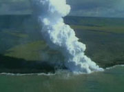
Some objects are too large to study well from the surface of the Earth. Again, hurricanes are a good example and so are earthquakes. Cracks in the Earth's crust, called faults, can cause earthquakes. Faults can be hundreds of miles long. Only satellites can see the entire fault at one time. Scientists and researchers around the world use NASA satellites. NASA's Earth Science Enterprise (ESE) and Earth Observing System (EOS) can study many natural hazards from space that can never be safely studied up close on Earth, such as fires, floods, storms, and volcanoes. Special instruments on these satellites can study hazards such as hurricanes in ways scientists can never study them on Earth. One satellite, called TRMM (Tropical Rainfall Measuring Mission), can "see" inside a hurricane. TRMM can tell that certain parts of hurricanes normally produce more rain. This information helps meteorologists forecast how much rainfall will affect people on the coast when hurricanes strike. Someday, this research may even help scientists forecast exactly where a hurricane will move onto land. Satellites allow scientists to observe remote parts of Earth that may be impossible to see except from space. Loss of trees in rainforests, the size of mountain glaciers and changes in our ozone layer can be measured best from space. Student Outcomes After viewing this video, students should be able to: Explain that satellites can be used to make measurements at a distance. (T: K-4) Key: C = climate / O = ocean circulation / T = 21st century technology / W = water cycle |
|||||