| NASA | GSFC | JPL | Site Map |
|
||
 |
 |
Education: Student Outcomes |
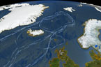
Click here to search for other assets Thermohaline Circulation Using Improved Flow Field Grade levels: 5-8, 9-12 Theme: ocean circulation Video: thermohaline_rev.flv
The animation also shows another feature of the global ocean circulation: the Antarctic Circumpolar Current. The region around latitude 60 south is the only part of the Earth where the ocean can flow all the way around the world with no obstruction by land. As a result, both the surface and deep waters flow from west to east around Antarctica. This circumpolar motion links the world's oceans and allows the deep water circulation from the Atlantic to rise in the Indian and Pacific Oceans, thereby closing the surface circulation with the northward flow in the Atlantic. The color on the world's ocean's at the beginning of this animation represents surface water density, with dark regions being most dense and light regions being least dense (see the animation Sea Surface Temperature, Salinity and Density). The depths of the oceans are highly exaggerated (100x in oceans, 20x on land) to better illustrate the differences between the surface flows and deep water flows. The actual flows in this model are based on current theories of the thermohaline circulation rather than actual data. The thermohaline circulation is a very slow moving current that can be difficult to distinguish from general ocean circulation. Therefore, it is difficult to measure or simulate. This version of the visualization combines the Earth look of the original thermohaline visualization with the new thermohaline flow field generated for the Science on a Sphere production, "Loop". (source) Student Outcomes After viewing this video, students should be able to: Explain the effect of density on ocean circulation. (O: 5-8) Explain the effect of solar energy heat on ocean circulation. (O: 5-8) Explain the influence of ocean salinity on the thermohaline circulation (e.g., "global conveyor belt"). (O: 9-12) Key: C = climate / O = ocean circulation / T = 21st century technology / W = water cycle |
|||||