| NASA | GSFC | JPL | Site Map |
|
||
 |
 |
Education: Student Outcomes |
Filtered by outcome, asset type: 9-12q4, video Click here to begin a new search | |||||||||||||||||||||||||||||||||||||||||||||||||||||||||||||||||||||||||
Outcome: Explain the influence of ocean salinity on the thermohaline circulation (e.g., "global conveyor belt"). | |||||||||||||||||||||||||||||||||||||||||||||||||||||||||||||||||||||||||
Grade level: 9-12 Theme: ocean circulation Video: density_effects.flv
But in the ocean it often happens that the reverse happens: so we might get something that's heavy, heavier (like) more dense waters on top of lighter water. And when that happens, we say that the ocean is unstable and we have "overturning". That means that the waters that are heavy come down to the bottom part of the ocean and those that are light need to go up. And that happens when waters are cooled and it also happens when the upper waters get saltier because of evaporation, etc. So those density differences mean that the ocean is going to circulate: it's going to move. And those density differences can come about because of temperature changes or salinity changes. Grade level: 9-12 Theme: ocean circulation Video: density_reverse_direction.flv
Grade level: 9-12 Theme: ocean circulation Video: sss_reverse_direction.flv
Grade level: 9-12 Theme: ocean circulation Video: thermohaline_conveyor_iPod.m4v.flv
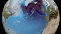
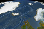
This animation shows one of the major regions where this pumping occurs: the North Atlantic Ocean around Greenland, Iceland, and the North Sea. The surface ocean current brings new water to this region from the South Atlantic via the Gulf Stream and the water returns to the South Atlantic via the North Atlantic Deep Water current. The continual influx of warm water into the North Atlantic polar ocean keeps the regions around Iceland and southern Greenland mostly free of sea ice year round. The animation also shows another feature of the global ocean circulation: the Antarctic Circumpolar Current. The region around latitude 60 degrees south is the the only part of the Earth where the ocean can flow all the way around the world with no land in the way. As a result, both the surface and deep waters flow from west to east around Antarctica. This circumpolar motion links the world's oceans and allows the deep water circulation from the Atlantic to rise in the Indian and Pacific Oceans and the surface circulation to close with the northward flow in the Atlantic. (source) Grade level: 9-12 Theme: ocean circulation Video: thermohaline_rev.flv
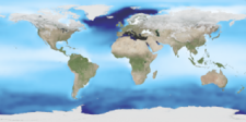
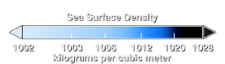
The animation also shows another feature of the global ocean circulation: the Antarctic Circumpolar Current. The region around latitude 60 south is the only part of the Earth where the ocean can flow all the way around the world with no obstruction by land. As a result, both the surface and deep waters flow from west to east around Antarctica. This circumpolar motion links the world's oceans and allows the deep water circulation from the Atlantic to rise in the Indian and Pacific Oceans, thereby closing the surface circulation with the northward flow in the Atlantic. The color on the world's ocean's at the beginning of this animation represents surface water density, with dark regions being most dense and light regions being least dense (see the animation Sea Surface Temperature, Salinity and Density). The depths of the oceans are highly exaggerated (100x in oceans, 20x on land) to better illustrate the differences between the surface flows and deep water flows. The actual flows in this model are based on current theories of the thermohaline circulation rather than actual data. The thermohaline circulation is a very slow moving current that can be difficult to distinguish from general ocean circulation. Therefore, it is difficult to measure or simulate. This version of the visualization combines the Earth look of the original thermohaline visualization with the new thermohaline flow field generated for the Science on a Sphere production, "Loop". (source) | |||||||||||||||||||||||||||||||||||||||||||||||||||||||||||||||||||||||||