| NASA | GSFC | JPL | Site Map |
|
||
 |
 |
Education: Student Outcomes |
Filtered by outcome: 9-12q7 Click here to begin a new search | |||||||||||||||||||||||||||||||||||||||||||||||||||||||||||||||||||||||||||||||||||||||
Outcome: Explain how new technology can enhance the gathering and manipulation of oceanic data. | |||||||||||||||||||||||||||||||||||||||||||||||||||||||||||||||||||||||||||||||||||||||
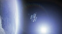
Grade level: 9-12 Theme: 21st century technology Video: aquarius_passive_satellilte.flv One thing to note about the Aquarius satellite is that it's what we call a "passive" satellite. Even though it takes a lot of work to get up there and a lot of people are working to put it up there, what it's doing is actually recording the wavelengths that the earth is radiating. So some satellites are "active": so they are sending a signal down through the atmosphere to earth's surface and then they are recording that signal that comes back. But when we're trying to measure the sea surface salinity, the Aquarius satellite will be recording the microwaves that the earth is sending back out to the atmosphere and space. Grade level: 9-12 Theme: 21st century technology Video: argo07_640x480.flv
This visualization shows the locations of the ARGO buoy array over time. When the buoys are above water, the lines are brighter; when the buoys are under water, the lines are fainter. The ARGO buoys measure ocean salinity, column temperature, and current velocities. (source) Grade level: 9-12 Theme: 21st century technology Video: global_ocean_04.flv
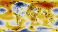
Paula Bontempi: "If the climate actually changes, and the oceans change or respond to that change, it most definitely will impact life as we know it, and especially humans." David Adamec: "To understand exactly how we stay here and how we're going to survive both within the climate, and even our life cycle, it requires understanding what the water is doing." Our climate is changing... in some places, faster than predicted. By using science to understand those changes, we can find ways of protecting our oceans - and ourselves - that make a world of difference. Grade level: 9-12 Theme: 21st century technology Video: global_ocean_03.flv
Other satellites show us peaks and valleys, not just on land - but, believe it or not - on the surface of the ocean. And as ice on land melts, there are increasingly more highs than lows. Sea level is rising. Grade level: 9-12 Theme: 21st century technology Video: global_ocean_01.flv
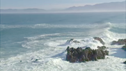
Paula Bontempi: "You can see the atmosphere, you can see the land, but you can't really see beneath the ocean's surface. So you start wondering, you know, what's going on beneath the part we can see." David Adamec: "We walk in a very small part of the atmosphere, and we walk on the land. And it's how that interaction takes place with the ocean, the atmosphere, and the land that determines our quality of life. Our goal is to understand the interconnectedness of it all." For years, people have worked to unravel the mysteries of the oceans. Scientists gather data from ships and buoys on the surface, take the plunge to explore ocean depths, and fly overhead to get a bigger picture. But one of the best views of oceans might be from way, way overhead. It's the view from space. Paula Bontempi: "The one thing that NASA satellites do that nothing else does, ships or buoys or anything else, is actually give you a picture of the globe within a few days. You get a much broader view of what's going on in some part of the Earth's system, and you can link that together to understand the Earth as a whole." Grade level: 9-12 Theme: 21st century technology Video: global_ocean_02.flv
David Adamec: "We are dependent on life in the water. Especially in the ocean. There are small plants called phytoplankton that are responsible for 50 percent of the oxygen that you're breathing right now." Grade level: 9-12 Theme: 21st century technology Video: aquarius_launch.flv Aquarius is going to be launched later this year. And one of the great things about it is that it has been in planning for a number of years and the launch is very exciting to all of those of us who have been working on it and looking forward to the launch. The main thing about it is that it is going to be giving us more data. So anybody who works in studying the oceans, the atmosphere, or the land on large scales is always interested in getting back more data. Because that just tells us a lot more about how the earth is working. Grade level: 9-12 Theme: 21st century technology Video: how_aquarius_works.flv
But some of that energy comes back at wavelengths that are micro-wavelengths. And the microwave lengths - the amount of energy that's emitted by the ocean - depends on the salinity. It is related to something we call the "brightness temperature". It all has to do with how much energy is emitted from the ocean back to the atmosphere, back out to space. And so if a satellite is sitting there, it's actually recording how much energy in that microwave segment is being emitted. And by the signal that it receives, it's able to "back out" (i.e., calculate) what the ocean salinity is. Grade level: 9-12 Theme: 21st century technology Article: documents/21.1_lagerloef.pdf
Now, we are pleased to report that a new satellite program scheduled for launch in the near future will provide data to reveal how the ocean responds to the combined effects of evaporation, precipitation, ice melt, and river runoff on seasonal and interannual time scales. These measurements can be used, for example, to close the marine hydrologic budget, constrain coupled climate models, monitor mode water formation, investigate the upper-ocean response to precipitation variability in the tropical convergence zones, and provide early detection of low-salinity intrusions in the subpolar Atlantic and Southern oceans. Read and discuss the text on the Aquarius/SAC-D mission design (p. 73-74). | |||||||||||||||||||||||||||||||||||||||||||||||||||||||||||||||||||||||||||||||||||||||