|
|
 |
|
|
|
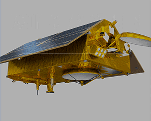
Jason-CS (Sentinel-6)
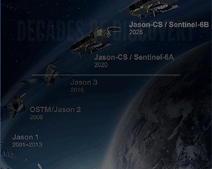
Mission Events
Jason-CS/Sentinel-6 Launch Plan: 2020
Mission Summary
The Jason-CS mission (on the Sentinel-6 spacecraft) is an international partnership between NASA, NOAA, the European Space Agency (ESA), and EUMETSAT.
Jason-CS will continue the high precision ocean altimetry measurements of the Jason-series satellites into the 2020–2030 time-frame using two successive, identical satellites, Sentinel-6A and Sentinel-6B.
A secondary objective of Jason-CS is to collect high resolution vertical profiles of temperature, using the GNSS Radio-Occultation sounding technique, to assess temperature changes in the troposphere and stratosphere and to support Numerical Weather Prediction.
RESPONSIBILITIES:
- NASA will provide the launch services for both Jason-CS satellites, a radio-occultation instrument based on a Tri-G receiver, AMR-C Microwave radiometer, and the same Laser Reflector Array as on the Jason-3 satellite, as well as and ground segment support. NASA will also contribute to the spacecraft operations and data processing.
- EUMETSAT is leading the system definition and is responsible for the ground segment development; operations preparation and operations of both satellites, and will co-fund the second satellite, together with the European Commission (EC).
- ESA is responsible for the development of the first satellite; the prototype processors; delivery of the LEOP services, and the procurement of the second satellite on behalf of EUMETSAT and the EC.
- The EC co-funds the second satellite with EUMETSAT and funds the operations of Jason-3 and both Sentinel-6 satellites, including the LEOP service for the second satellite.
- NOAA provides U.S. ground stations for data down links.
BENEFITS:
 - Measurements of ocean topography, being the equivalent of surface pressure in the atmosphere, are enabling numerical prediction of the three-dimensional ocean, which is a prerequisite to the development of operational oceanography in synergy with marine meteorology.
- The development of operational oceanography is, in turn, necessary to improve forecasts of the weather conditions likely to prevail two to four weeks ahead (monthly forecasts), e.g. heat waves or sustained heavy downpours, and in the next seasons (seasonal forecasts) e.g. a cold winter or a hot summer, as a result of the sustained influence of the ocean on the atmosphere.
- Variations of sea level (some mm per year) in our changing climate can only be monitored on global scale by HPOA observations, and ocean surface topography measurements are essential to understand how the ocean stores and redistributes heat, water and carbon in the climate system.
Additional Information
Scientific Instrument(s)
 - Radar altimeter; developed by ESA, based on the Sentinel-3 SARL instrument, with a design adopted to allow the interleaved mode combining SAR and LRM modes;
- AMR-C Microwave radiometer; provided by NASA;
- GNSS Precise Orbit Determination (POD) Receiver; developed by ESA and derived from the GNSS Receiver on Sentinel-3;
- Doppler Orbitography and Radiopositioning Integrated by Satellite (DORIS) Receiver; same as on Jason-3 and Sentinel-3; provided by CNES
- Laser Reflector Array (LRA); same as on Jason-3, provided by NASA;
- GNSS-Radio-occultation (GNSS-RO) instrument; based on a Tri-G receiver, provided by NASA.
|
|
|
|
|
|
|
|
|

