| NASA | GSFC | JPL | Site Map |
|
||
 |
 |
Education: Student Outcomes |
Filtered by theme: climate Click here to begin a new search | ||||||||||||||||||
Grade levels: 5-8, 9-12 Themes: 21st century technology, climate, water cycle Flat Tool: http://ourocean.jpl.nasa.gov/AQUARIUS/chp3.jsp GoogleEarth Interface Tool: http://aquarius.jpl.nasa.gov/AQUARIUS_DEV/chp3.jsp Create global maps of mean conditions for any year(s) from 1800 to 2005 at designated depths (down to 1500m) using the pull-down menus. Annual time-series graphs of salinity, temperature, or density can be plotted by selecting up to six locations (by clicking on the map or typing latitude/latitude information into the fields below). These time-series graphs can also represent up to six different depths. Plotted data will also be shown in a table that is easily downloaded (e.g., into Excel). Source is actual, non-interpolated database measurements. Focus Questions | Flat Tool Tutorial | ||||||||||||||||||
Grade level: K-4 Theme: climate Activity: http://www.nationalgeographic.com/xpeditions/lessons/01/g35/tgcontinents.html Consider distance from an ocean in this lesson where students examine a map and globe for comparison of the physical features of Earth's continents. Students will play the GeoSpy continents game and manipulate an online map, then write paragraphs comparing and contrasting two continents. The idea for this lesson plan was inspired by Suzie Howell-Olsen and Katie Hansen of Meadow School in Petaluma, California, who received a teacher grant from the National Geographic Education Foundation in support of a year-long project called A Survey of the Continents. | ||||||||||||||||||
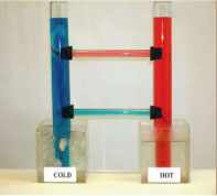
Grade levels: 5-8, 9-12 Themes: climate, ocean circulation Activity: http://www.tos.org/hands-on/teaching_phys_concepts.pdf
The purpose of this activity is to review basic concepts of thermal physics and highlight applications to ocean processes by focusing on the concept of convection. Convection and advection are the major modes of heat transfer in the ocean and atmosphere. Convection occurs only in fluids and involves vertical motion of fluid, or flow, rather than interactions at the molecular level. It results from differences in densities - hence buoyancy - of fluids. Examples of convective processes include: currents in Earth's mantle, which drive the tectonic system and result from heating and cooling of magma; atmospheric circulation resulting from uneven solar heating (e.g., between the poles and the equator); the global ocean conveyor belt and formation of deep water masses, resulting from cooling of surface water at high latitudes; and vertical mixing in the ocean's upper layer due to variations in heating between day and night. Advection usually refers to horizontal transfer of heat with the flow of water (e.g., the Gulf Stream). Read the following sections of Chapter 4 (Heat and Temperature) in preparation for this activity: • Background (p. 32) • Mechanisms of Heat Transfer (p. 33) Videos
Flash Video | QuickTime Movie
| ||||||||||||||||||
Grade level: 9-12 Theme: climate Activity: http://www.pbs.org/newshour/extra/teachers/lessonplans/science/jan-june08/polar_oceanography.html
Part III: Ocean Currents and Coastal Climates. Do ocean currents affect coastal climates? Resources provided with this activity enable students to access climatic data for two communities: St. Mawgan, England, and Daniels Harbour, Newfoundland, Canada. Both communities are located near 50°N latitude. St. Mawgan is situated on the southwestern coast of England along the eastern shores of the Atlantic Ocean. Daniels Harbour is located in Newfoundland near the western shores of the Atlantic Ocean. Students will collect, process, and analyze climate data to answer questions on temperature patterns, prevailing winds, and the Gulf Stream. | ||||||||||||||||||
Grade level: 5-8 Theme: climate Video: atmosphere_ocean_fluids.flv Currently we have a 50 degree Fahrenheit difference between the temperatures around the equator and the temperatures at the high latitudes near the poles. So that's 50 degrees Fahrenheit difference. Now without those fluids - so if the earth didn't have an atmosphere and the earth didn't have an ocean (which might not make it very livable) - but if we just had a solid land planet, that temperature difference would be 200 degrees Fahrenheit. So it really gives you an idea of how much work those fluids are doing and how much heat they're delivering from the equator to the poles. | ||||||||||||||||||
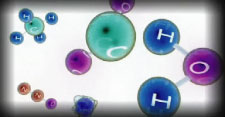
Grade level: 9-12 Theme: climate Article: documents/v39n2-schmitt_2174.pdf As with similar questions about a tree in the forest or a grain of sand on the beach, it may be hard to imagine that a few inches of rain matters to the deep ocean. After all, the ocean's average depth is around 4 kilometers and only 1 to 5 centimeters of water are held in the atmosphere at any one time. But it does matter, in part because the ocean is salty. The effect of rain diluting the salts in the ocean (or evaporation concentrating them) can be greater than the effect of heating (or cooling) on the density of seawater. | ||||||||||||||||||
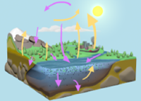
Grade level: 9-12 Themes: climate, water cycle Video: keeping_up_carbon_03.flv
Researchers are learning that future climate change will depend on carbon levels in the land, in the atmosphere, and in the sea, and how these levels respond to human disturbance. About one-third of all human-generated carbon emissions has dissolved into the ocean. More than 80% of Earth's added heat is now stored in the ocean. Scott Doney: "In the future, as the planet gets warmer, the water's going to warm up, and warm water can hold less carbon than cold water - the other thing is, on a warmer planet, some of the currents are going to slow down, so we might not be forming as much of this cold deep water. So we won't be able to transport carbon into the deep sea. So on the whole, the ocean's going to become less effective at removing carbon from the atmosphere." (source) | ||||||||||||||||||
Grade level: 9-12 Themes: climate, water cycle Video: keeping_up_carbon_04.flv
Stacey Boland: "As the ocean absorbs more carbon dioxide, it becomes more acidic, and this can be a threat to some of the organisms that live inside the ocean." As Earth's climate continues to change, how will researchers monitor something as big as the ocean, and something as complex as the carbon cycle? NASA Earth observing satellites give scientists the "big picture" view of our home planet. Varied satellites help researchers detect changes in ocean climate and ecology over time, providing vital insight into the health of our home planet. (source) | ||||||||||||||||||
Grade level: 9-12 Theme: climate Video: keeping_up_carbon_01.flv
Understanding the carbon cycle - and how it is changing - is key to understanding Earth's changing climate. On land, plants remove carbon from the atmosphere through photosynthesis. Animals eat plants and either breathe out the carbon, or it moves up the food chain. When plants and animals die and decay, they transfer carbon back to the soil. Moving offshore, the ocean holds huge amounts of carbon - about 50 times the amount we find in the atmosphere. Stacey Boland: "The ocean is sometimes called a carbon sink, meaning that it absorbs, or takes up carbon from the atmosphere. It takes up carbon through physical and biological processes." (source) | ||||||||||||||||||
Grade level: 9-12 Theme: climate Video: keeping_up_carbon_02.flv
Over long time scales, this process has made the ocean floor the largest reservoir of carbon on the planet. Most of the ocean's nutrients are in cold, deep water. In a process called upwelling, currents bring nutrients and carbon up to the surface. Carbon can then be released as a gas back into the atmosphere, continuing the carbon cycle. By cycling huge amounts of carbon, the ocean helps regulate climate. Scott Doney: "So when you think of climate, you don't often think of the ocean. With climate - you think of, is it going to be hotter this year, or is it going to be colder this year? But the oceans are actually a great regulator, a controller of Earth's climate. And they even are controlling how much carbon is in the atmosphere, which can slow down how quickly climate change is occurring." (source) | ||||||||||||||||||
Grade level: K-4 Theme: climate Tool: http://blueplanetbiomes.org/climate.htm
Climate is the characteristic condition of the atmosphere near the earth's surface at a certain place on earth. It is the long-term weather of that area (at least 30 years). This includes the region's general pattern of weather conditions, seasons and weather extremes like hurricanes, droughts, or rainy periods. World biomes are controlled by climate. The climate of a region will determine what plants will grow there, and what animals will inhabit it. All three components, climate, plants and animals are interwoven to create the fabric of a biome. Compare land biomes in this tool with ocean biomes. | ||||||||||||||||||
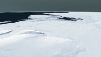
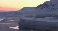
Grade level: 9-12 Themes: climate, ocean circulation, water cycle Video: melting_ice_03.flv
Lora Koenig: "Even though the polar regions seem very far from a lot of people's day to day life, they are very important. Because they are regions that cool our earth. And as they change, they're going to cause larger changes throughout the rest of the globe." (source) | ||||||||||||||||||
Grade level: 9-12 Themes: climate, ocean circulation, water cycle Video: melting_ice_02.flv
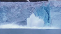
Lora Koenig: "What we're seeing right now on the ice sheets and glaciers is that they are shrinking in size. And as glaciers on land are shrinking overall, that contributes a little bit to sea level rise. And we are worried that as we see warming over the ice sheets, and increased melting over the ice sheets, that they are going to start contributing much more to sea level rise." (source) | ||||||||||||||||||
Grade level: 9-12 Themes: climate, ocean circulation, water cycle Video: melting_ice_04.flv
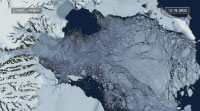
Josh Willis: "As the great ice sheets in Antarctica and Greenland begin to melt and break up due to global warming, we really might experience very rapid sea level rise; three or four times as fast as the rate that we see today. So predicting this rate out into the future is very tricky because we really don't know when the ice sheets might break up and how fast they will when they do. So predicting future sea level rise is one of the great scientific problems of the future." (source) | ||||||||||||||||||
Grade level: 9-12 Themes: climate, ocean circulation, water cycle Video: melting_ice_01.flv
Josh Willis: "I prefer not to think about climate change and global warming in terms of doom and gloom scenarios, so much as a change in our planet. Our planet's definitely changing, and we're definitely causing it. So we're going to have learn to deal with some of these changes. But in addition, we're going to have to learn how to make a slightly smaller footprint on our planet." Josh Willis: "Sea level is rising effectively because of global warming. As the planet heats up, two things happen to the ocean. One is that the temperature of the water increases. And as that happens, the water actually expands and takes up more room. The other thing that happens is that ice that was on land in the form of glaciers and ice sheets begins to melt and as that runs off into the ocean, it increases the water in the ocean, and it actually raises sea level as well. (source) | ||||||||||||||||||
Grade level: 9-12 Theme: climate Activity: http://mynasadata.larc.nasa.gov/preview_lesson.php?&passid=9 The purpose of this activity is to discover the link between ocean temperatures and currents as related to our concern for current climate change. After completing this activity, students will:
| ||||||||||||||||||
Grade level: K-4 Theme: climate Tool: http://www.windows.ucar.edu/tour/link=/earth/Water/marine_ecology.html
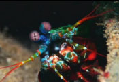
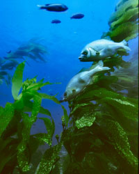
Life in the ocean is diverse. The smallest creatures that call the ocean home are so tiny that they can only be seen with a microscope. The largest creatures are blue whales, which can be as much as 34 meters (110 feet) long. There are many different ways to live in the ocean, too. Some animals travel huge distances through ocean water. Others stay in the same place on the ocean floor their entire lives. Some burrow beneath the sand while others float near the surface. The ocean is not the same everywhere. There are many different ecosystems within the ocean depending on conditions such as the water temperature, the amount of sunlight that filters through the water, and the amount of nutrients. Sunlight breaks through the top layer of ocean water. It can make its way as deep as 200 meters (656 feet). Almost all marine life (about 90 percent) lives within this top, sunlit layer of the ocean. There, phytoplankton, algae, and plants like seagrass make their own food through the process of photosynthesis and are the start of most marine food chains. The temperature of ocean water varies depending on its location. Water near the polar regions is colder than water near the equator. Water that is deep in the ocean is colder than water that is near the ocean surface. Many animals and other organisms can only survive at certain temperatures. Others are able to survive at a range of temperatures and can live in more places in the ocean. Compare ocean biomes in this tool with land biomes. | ||||||||||||||||||
Grade levels: 5-8, 9-12 Themes: climate, ocean circulation Tool: http://oceanmotion.org/html/resources/oscar.htm This data visualizer gives access to the following global ocean surface current behaviors between 1992 and 2008: current speed, current direction, current convergence, and current vorticity as well as the anomaly values for each. | ||||||||||||||||||
Grade level: 5-8 Theme: climate Tool: http://oceanmotion.org/html/resources/winds.htm This data visualizer includes wind speeds and directions from 1999 to 2008. | ||||||||||||||||||
Grade level: 5-8 Theme: climate Video: salinity_and_climate_2.flv One of the concerns we've had is whether or not the salinity changes will impact what's called the very large-scale ocean overturning circulation, what many people refer to as "the global ocean conveyer belt". And so that overturning of the ocean plays a large role in our climate. And not just (sort of) a climate that we think of in a really abstract sense but it really means a lot for the climate that we live in because that ocean overturning redistributes the heat. | ||||||||||||||||||
Grade level: 5-8 Theme: climate Video: salinity_and_climate_1.flv
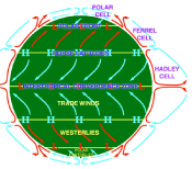
So these warm waters are returning at the surface, going back to those high latitudes in the Norwegian and Greenland seas. And when they're doing that, when they're returning, they're bringing very warm water with them. Because that return means they're coming through the equatorial regions of the tropics where the atmosphere is very warm and the oceans are warmed. So when those warm waters are returning, as they're moving up to the higher and higher latitudes, then they're releasing that heat to the atmosphere. Then the winds blow over the ocean, they pick up that heat, and those winds over the Atlantic Ocean are moving from the North American continent to the European continent. So these westerly winds are picking up that heat and moisture and dumping it all over the British Isles and northern Europe. So if there's any change to that overturning circulation, that means that northern Europe and the British Isles would be robbed of that heat, due to those waters that are returning to the high latitudes. | ||||||||||||||||||
Grade levels: 5-8, 9-12 Themes: climate, ocean circulation, water cycle Video: salt_of_earth_03.flv
Jeff Halverson: "Climate change on earth is complicated by the fact that the ocean moves much more slowly than the atmosphere. So you have warming in the atmosphere, warming in the ocean, but they're occurring at different speeds. So they're out of sync, and that makes predicting what's going to happen in the next hundred or two years very, very difficult." Susan Lozier: "Now what we might expect happens, in a very simplistic sense, is that as the ocean warms, there's going to be more evaporation. And that more evaporation would would mean that oceans become saltier. But really it's not just that simple because there's also evaporation, precipitation, and the ice as well, and that's all wrapped up in the study of the hydrologic cycle." (source) | ||||||||||||||||||
Grade levels: 5-8, 9-12 Themes: climate, ocean circulation, water cycle Video: salt_of_earth_02.flv
Jeff Halverson: "It takes perhaps a thousand years for the water to cycle through the deep ocean. So we say the oceans have a memory. They're like a tape recorder. Things that happen now will still be manifest hundreds of years in the future as that cold water moves through this giant circulation." Susan Lozier: "So if there's any change to that overturning circulation, that means that Northern Europe and the British Isles would be robbed of that heat due to those waters that are returning to the high latitudes." (source) | ||||||||||||||||||
Grade levels: 5-8, 9-12 Themes: 21st century technology, climate, ocean circulation, water cycle Flat Tool: http://ourocean.jpl.nasa.gov/AQUARIUS/chp1.jsp GoogleEarth Interface Tool: http://aquarius.jpl.nasa.gov/AQUARIUS_DEV/chp1.jsp Interactive maps of surface conditions can be clicked to create in-water profiles of salinity, temperature, or density. Sources include interpolated atlas data or actual measurements from the database. Focus Questions | Flat Tool Tutorial | ||||||||||||||||||
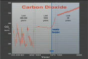
Grade level: 9-12 Theme: climate Video: CarbonCycleFinal_ipod.m4v.flv
On land, plants remove carbon from the atmosphere through photosynthesis. Animals eat plants and either breath out the carbon, or it moves up the food chain. When plants and animals die and decay, they transfer carbon back to the soil. Moving offshore, the ocean takes up carbon through physical and biological processes. At the ocean's surface, carbon dioxide from the atmosphere dissolves into the water. Tiny marine plants called phytoplankton use this carbon dioxide for photosynthesis. Phytoplankton are the base of the marine food web. After animals eat the plants, they breathe out the carbon or pass it up the food chain. Sometimes phytoplankton die, decompose, and are recycled in the surface waters. Phytoplankton can also sink to the bottom of the ocean, where they become buried in marine sediment. Over long time scales, this process has made the ocean floor the largest reservoir of carbon on the planet. In a process called upwelling, currents bring cold water containing carbon up to the surface. As the water warms, the carbon is then be released as a gas back into the atmosphere, continuing the carbon cycle. Carbon is found in the atmosphere as carbon dioxide, which is a greenhouse gas. Greenhouse gases act like a blanket, and trap heat in the atmosphere. In the past two centuries, humans have increased atmospheric carbon dioxide by more than 30 percent, by burning fossil-fuels and cutting down forests. (source) | ||||||||||||||||||
Grade level: 5-8 Theme: climate Activity: documents/vtop_coastal_v_inland_temps.pdf In this activity, students will use the weather section of the newspaper to help discover why coastal regions have relatively moderate climates. They will construct models of the ocean and the land to measure the different cooling and warming rates of each. | ||||||||||||||||||
Grade level: 5-8 Theme: climate Activity: documents/vtop_global_winds_oc_currents.pdf The surface currents of the major ocean basins show similarities to the prevailing wind systems that drive them. Contained by continental boundaries and deflected by Earth's rotation, these surface currents flow in large, roughly circular patterns called gyres. Gyres play an important role in redistributing heat from the low to middle and high latitudes, thus influencing air temperature, weather, and climate. After completing this investigation, students should be able to (1) demonstrate the influence of wind on ocean currents, and (2) describe the typical gyre circulation of surface currents in two major ocean basins. | ||||||||||||||||||
Grade level: 5-8 Theme: climate Activity: documents/vtop_oc_currents_coastal_temp.pdf The surface currents of the major ocean basins show similarities to the prevailing wind systems that drive them. Contained by continental boundaries and deflected by Earth's rotation, these surface currents flow in large, roughly circular patterns called gyres. Gyres play an important role in redistributing heat from the low to middle and high latitudes, thus influencing air temperature, weather, and climate. After completing this investigation, students should be able to (1) demonstrate the influence of wind on ocean currents, and (2) describe the typical gyre circulation of surface currents in two major ocean basins. | ||||||||||||||||||