|
|
 |
|
|
|
|
|
02.21.2013
The Association of Polar Early Careers Scientists (APECS) is an organization for undergraduate and graduate students, postdoctoral researchers, early career faculty members and educators with interests in Polar Regions. APECS developed during the 4th International Polar Year (IPY 2007-2008) with the primary objectives of stimulating interdisciplinary and international research collaboration and developing effective future leaders in polar research, education and outreach.
MORE >>
|
|
|
02.21.2013
The COSEE Florida Ocean Science Learning Network takes advantage of the abundance of high quality informal education centers across the state. The community-based centers have proven to be ideal venues for connecting ocean scientists to local audiences, including collaborations with educators, because of their well established school and public outreach programs.
MORE >>
|
|
02.21.2013
NC OPT-ED & COSEE SouthEast are working together to increase exposure to ocean sciences to underrepresented minority students in North Carolina.
MORE >>
|
|
02.21.2013
COSEE West – Colorado Collaborative is a partnership that focuses on making ocean sciences relevant to inland audiences; it also exposes teachers from the interior Southwest and Southern California to ocean-/climate-related issues faced by each.
MORE >>
|
|
02.21.2013
COSEE-CA researchers have developed a survey that measures understanding and attitudes about the ocean and the role that ocean sciences play in supporting understanding of Earth systems. A measure of ocean literacy, or the understanding of the mutual impact between humans and the ocean, is necessary to properly assess where awareness of ocean concepts is lacking and for potential interventions.
MORE >>
|
|
02.21.2013
Since 2008, educators have convened for five days during the summer at UCLA, USC and three informal science center partners; NASA/Jet Propulsion Laboratory, Ocean Institute and Cabrillo Marine Aquarium. Throughout the day, hands-on activities engage educators in marine science concepts, ocean observing technology, how to collect data and use online data in the classroom. Each day a featured researcher presents their research using drifters, gliders, satellites or other ocean observing technology, followed by questions and answers. Ocean Literacy Principles are tied to lessons and activities.
MORE >>
|
|
02.21.2013
The Marine Advanced Technology Education (MATE) Center and COSEE NOW are using ocean drifters to teach college students about the interrelationship of ocean processes and understand how oceanography relies on technology to observe and measure the state of the oceans.
MORE >>
|
|
02.21.2013
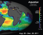
The Aquarius mission is brimming with educational content that hits all four areas of STEM: science, technology, engineering and mathematics. The design and engineering of the satellite, the science of ocean observing, the technical specifications for the mission and the importance of understanding global processes through data can all be illustrated using Aquarius as an example.
In this poster, NASA’s education and outreach team illustrates their multi-pronged approach to creating educational products and opportunities for educators to utilize information and data about Aquarius.
MORE >>
|
|
02.21.2013
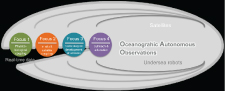
The OAO (Oceanographic Autonomous Observations) team operates automatic platforms such as gliders and profiling floats and is also strongly implicated in the technological development of their "new generation" in terms of scientific payloads. The acquired multi-sensor data, particularly focusing on marine biogeochemically-relevant data (e.g. oxygen, nitrate, chlorophyll-a, amount of light penetrating the Ocean) together with temperature and salinity, then serve within the wide fields of fundamental research and operational applications. Within this framework and making use of the exceptional characteristics of such autonomous platforms (e.g. multidisciplinary real-time data in high resolution, possibility for sub-regional to global perspectives), the OAO team also seeks to contribute the more and more towards educational and outreach activities. On a local/and international basis, thus several activities are proposed and the development of attractive outreach approaches is undertaken.
MORE >>
|
|
02.21.2013
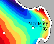
Process studies employing autonomous underwater vehicles (AUVs) off central California have advanced the scientific understanding of harmful algal blooms (HABs), as well as the educational resources to explain them. These process studies gathered multidisciplinary observations from AUVs, moorings, ships, aircraft, and satellites. Moored systems included autonomous robotic biochemistry systems for in situ detection of HAB species and toxins.
Integrating the knowledge gained from a series of process studies, we developed a visualization of processes that influence bloom ecology in Monterey Bay, California. This visualization, rendered to static and dynamic content, emphasizes how HAB ecology is profoundly influenced by processes that originate at the boundaries of coastal marine ecosystems. In its dynamic form, the illustration is presented in language that is accessible to resource managers and the general public.
MORE >>
|
|
02.21.2013
A poster presentation of the Lamont-Doherty Secondary School Field Research Program in Piedmont Marsh, including a description of the marsh, list of participants, and information on plankton tows, sediment accretion, fish, phragmites, soil carbon, hydrology, and nutrients concentrations.
MORE >>
|
|
02.21.2013
The upper layers of the Canadian Basin constitute a large reservoir of freshwater and buoyancy that derives from river runoff, sea-ice meltwater, and relatively fresh North Pacific waters. We use salinity, oxygen isotopes and nutrient concentrations to study the varying contribution from freshwater components in a series of Arctic Ocean cruises between 1989 and 2005.
MORE >>
|
|
02.21.2013
The Mediterranean, a semi-enclosed regional sea with more than twenty riparian states, has its specificities and characteristics from an environmental and societal point of view. It represents a challenging “playground” for all concerned, including actors within the fields of research or decision-making. In the light of this, it also seems necessary to develop strategies and collaborations to educate and outreach on “Mare nostrum” and the today’s challenges associated.
MORE >>
|
|
02.21.2013
We believe that public outreach is one of our duties to society. We organize activities in order to popularize oceanography and the impact of climate change on marine ecosystem in the schools. The activities are mainly proposed to 10-12 year old children and they are organized in two meetings. These activities started in the framework of the European IP Project SESAME (Southern European Seas: Assessing and Modeling Ecosystem changes), but they continue today.
MORE >>
|
|
02.21.2013
In 2007, The Island School launched the BESS Program targeting the next generation of Bahamian leadership who will be most important for the social, environmental, and economic stability of this island nation.
BESS students enroll in a year-long, high school post-graduate program that includes a semester at The Island School and a six-month internship at a conservation-related organization such as Bahamas Reef Environment Education Foundation, the Bahamas National Trust, or the Cape Eleuthera Institute. The internship gives students real-world work experience and helps them develop an understanding of the environmental and conservation issues that are of primary importance to The Bahamas.
MORE >>
|
|
 02.21.2013
Four COSEE Centers - Ocean Systems, West, Networked Ocean World, and California - held concept mapping collaborative workshops to help scientists mentor graduate students to improve their teaching and research. Formative and summative evaluation results indicate that the workshops promoted more peer to peer interactions between faculty and graduate students and more familiarity with Ocean Literacy and Climate Literacy principles.
MORE >>
|
|
01.03.2013
MSNBC presents physical illustrations which explain what happens in after an oil spill. The slides show different ways that oil can spread into the rest of the environment, including into the air (via evaporation) and into deeper water (via dissolution). Useful as supplementary material for students in middle and high school.
MORE >>
|
|
12.19.2012
The US Environmental Protection Agency (EPA) created this booklet to show its findings on global climate change to the public. The 80-page packet contains accessible and easy-to-understand explanations of many of the phenomena associated with global climate change and dozens of graphs to show the scientific support for the theory. This packet includes chapters on greenhouse gases, ocean changes, and snow/ice melting. Useful as supportive material for high school courses covering climate change.
MORE >>
|
|
12.19.2012
The National Geography presents this exemplary educational page complete with written activity summaries, video/photographic support references, and methodical lesson plans for each of dozens of educational activities. The topics range from marine protected areas to oil spills and encompass biological, chemical, physical and management perspectives. There are activities for all grade levels.
MORE >>
|
|
12.19.2012
Fit for grades 3-8, this is the lesson plan for a hands-on demonstration of how the moon and sun affect the ocean in the form of tides. Students join hands in a circle to simulate the world’s oceans, and lean back in order to demonstrate the pull of celestial bodies on the water.
MORE >>
|
|
12.19.2012
The World Resources Institute has created an interactive map detailing the world’s ocean dead zones. A dead zone is a region of eutrophication and/or hypoxia- zones where algae have bloomed (usually due to human-made reasons) and removed most of the dissolved oxygen from the water, making it impossible for other marine life to survive in that area. This map shows dots indicating dead zones across the globe and even includes click-able pop-ups to give more information about the area and possible causes for the deadzone.
MORE >>
|
|
12.14.2012
A compilation of resources related to marine microbes from the Center for Microbial Oceanography: Research and Education (C-MORE).
MORE >>
|
|
12.12.2012
This activity, made by the COSEE West program, gives a visual demonstration of the effects of increased acidity in seawater. Using dry ice, a natural indicator such as red cabbage dye, and a pH meter, students can see what happens when a lot of carbon dioxide is placed into water. The color change in the cabbage dye indicates the change in acidity, and that change can then be quantitatively measured using a pH meter or pH paper.
MORE >>
|
|
12.12.2012
This activity, made by the COSEE West program, gives a tactile demonstration of the effects of increased acidity in seawater. The lesson plan has the students douse egg shells, sea shells, coral skeleton, or other calcified animal products in various liquids including vinegar, lemon juice, and soda water to see the effect that increased acidity has on marine organisms. Students are encouraged to look at the pH of the liquid by using pH paper, red cabbage juice as an indicator, or a pH meter, and then study the effect that acidic solutions have on calcium-carbonate based products. (High School)
MORE >>
|
|
12.03.2012
This activity booklet created by NOAA encourages ocean stewardship ideas to younger elementary students (K-3). This activity book can be printed out for a fun and educational afternoon! These pages include a word search, fun facts about marine debris, tips about packing a more marine friendly lunchbox, coloring pages and information about marine sanctuaries around the United States. This NOAA-created activity is geared toward kindergarten through 3rd grade students.
MORE >>
|
|
|
|
|
|
|
|
|
|