Initiated in fall 2005,
COSEE-OS has been fostering educator-scientist relationships to guide the creation of high quality resources that address fundamental concepts and are applicable beyond the coasts. Home to large cities, coastal fishing towns, inland farming communities, and world-class marine research, northern New England is an ideal test-bed for developing, implementing, and testing innovative new practices, tools, and techniques for ocean sciences education. Mid-way through the initial funding cycle, COSEE-OS is making significant progress towards our ultimate goal: test locally, deliver globally.
Our greatest success in nurturing educator-scientist teams has been through our home institutions: University of Maine (UMaine), University of New Hampshire (UNH), and Bigelow Laboratory for Ocean Sciences. From our first kick-off meeting to our recent site visit from the National Science Foundation (NSF), we have provided opportunities for close interaction between educators and researchers, continually striving to improve the quantity and quality of collaboration.
| |  |
|
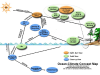
In October 2005, the COSEE-OS kick off meeting involved educators and researchers who analyzed Ocean Literacy principles with the goal of selecting a thematic focus for the first set of major COSEE-OS deliverables. Based on community input, COSEE-OS was directed to develop resources and tools addressing the Ocean Literacy principle, "The ocean is a major influence on climate." This meeting was followed by a one-day concept mapping training session for research scientists. In addition to learning a new and valuable technique, participants were able to reach consensus on which high priority ocean-climate concepts would be included in COSEE-OS resources and materials.
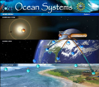
In addition to designing the framework for the main page of the COSEE-OS Ocean-Climate Interactive (OCI) website, scientists and educators collaborated on a series of concept maps that parse content among three distinct views: Earth-Sun System View, Earth View, and Close-Up View. Over three years, these maps have been translated into the visually attractive entry point for access to COSEE-OS resources, such as images, videos, news items, and teaching resources. (Take the online OCI tutorial.)
To ensure the excellence of its recommended teaching resources, COSEE-OS has formed review teams that include a scientist, a classroom teacher, and an informal educator. Through participation in this process, scientists have realized that a general lack of information on fundamental science concepts can impair otherwise outstanding educational materials. Based on this activity, COSEE-OS is compiling a gap analysis of resources that educators need in order to understand the ocean-climate system, but that are not readily available online. Such an analysis may help scientists better address broader impact requirements on NSF proposals.
A great deal of resource testing and subsequent improvement takes place through five-day summer educator workshops at UMaine and UNH. UMaine's
Teaching Sciences by Ocean Inquiry workshop explores the dynamics of teaching science using ocean examples. To better reach non-traditional ocean education audiences, focus is placed on physical (i.e., rather than biological) science concepts such as density, waves, pressure, and energy. Goals are to: 1) help teachers develop inquiry-based units for teaching physical concepts using oceans and their climate links as a vehicle; and 2) develop a network between teachers, scientists and experts in education. Per COSEE-OS's goal to make ocean content applicable beyond the coasts, the geographic reach of the workshops has grown considerably in only two years. In 2006, our first set of workshops attracted applicants from predominantly coastal areas on the eastern seaboard (i.e., Maine to Georgia). In 2008, the 80-plus workshop applicants hailed from faraway and/or inland states, including Colorado, Idaho, New Mexico, and Arizona.
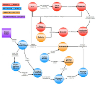
Coincident with an NSF site visit by Lisa Rom and Don Elthon, the 2008 UNH Seasonal Change in the Ocean summer educator workshop targeted the use of the newly developed COSEE-OS Concept Map Builder (CMB) tool as a way to assess the translation of content from scientists to educators. Weeks before the UNH workshop, four of the featured scientists were asked to create concept maps that covered the material they planned to present to the workshop educators. Each of the scientists was paired with Center staff who created interactive concept maps tied to existing resources on the COSEE-OS website. By simultaneously logging onto the Concept-Linked Integrated Media Builder (CLIMB), the scientists and COSEE-OS staff were able to adjust the maps through several iterations before reaching the final versions.
 | |
|
At the onset of the workshop, small teams of educators were given subsets of the concepts as "stickies" and asked to predict Prof. Morrison's story based on those concepts. The teams then discussed how the various sub-stories might fit together during the keynote presentation. After the talk, these teams relocated and re-linked concepts based on what they had learned. Morrison told NSF Program Managers that this exercise gave him unprecedented and immediate feedback on his talk, and helped him to see how to improve his presentations in the future. As the week of scientists' presentations progressed, the educators updated their concept maps to reflect the scope of what they had learned.
To aid in preparation of lesson plans, the educators were instructed on the use of the CMB. In addition, they were given direct access to the online maps - and linked resources - co-created by the scientists specifically for the workshop. A few educators chose to copy and repurpose portions of the scientists' maps; however, most took the plunge and created new maps from scratch. (Take the online Concept Map Builder tutorial. To access the UNH 2008 workshop materials, click here. To learn more about concept mapping tools, please contact Annette deCharon.)
Visit COSEE-Ocean Systems!
Contributed by Annette deCharon
Photos by Jennifer Albright, Amy Cline and Christy Herren