How Educators are Using COSEE-OS Multimedia Tools in “Real World” Classrooms
COSEE-OS is dedicated to fostering substantive dialogue between scientists and educators. With this in mind, we have developed an applied concept-mapping process and related suite of interactive multimedia tools that focus on ocean and climate concepts. Concept maps are graphical tools for visualizing and organizing ideas and processes, and displaying the relationships among concepts using connecting lines and descriptive phrases. COSEE-OS research has revealed that concept mapping benefits scientists by exposing what they do and do not explain well to audiences of educators, and promotes true peer-to-peer learning environments for both parties. The following three ‘mini-case studies’ describes how three very different COSEE-OS educators are currently utilizing our multimedia tools in real world classrooms to help their students understand complex and often confusing science topics (e.g., global warming, climate change, ocean acidification, and sea level rise). Flexibility of the tools and the concept mapping process is a key element that allows educators to use these online resources in many novel ways.
Case Study 1: Drawing in a New Crowd of Ocean Science Literate Citizens
| |
|
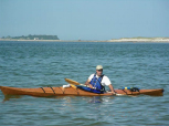
| Bob Khederian, a COSEE-OS Educator of oceanography for non-science majors |
|
Robert (Bob) Khederian, a faculty member who teaches oceanography at the New England Institute of Art in Brookline, MA, found out about the COSEE-OS multimedia tools and the concept mapping process in October 2008 at the Ocean Literacy (OL) Summit - hosted by the New England Ocean Sciences Education Consortium (NEOSEC). He teaches non-science major college students earning bachelor degrees in graphic and web design, interactive audio & media technology, etc.- a completely new audience for COSEE-OS! Bob is an electrical engineer by training who worked in industry for many years before deciding to pursue a career in teaching at the university level. Rather than let an oceanography course be dropped in his department, Bob decided to teach himself the material and draw upon his physical sciences knowledge to carry the course forward over the last three years. His passion in education is to infuse students from all walks of life with an appreciation of ocean science in order to build an informed and active citizenship – he constantly stresses how the natural world affects their everyday lives.
 | |
Rubric concept map created by Bob as a guiding example for his students before they tackled their final exam | |
Before attending COSEE–OS workshop at the OL Summit, Bob was not familiar with concept mapping, but afterward realized this educational technique would allow him to “step out of the box” in his course by utilizing a creative tool that appealed visually to his students. He does not like giving long finals stocked with questions requiring “regurgitation” of answers only, so he decided to pose a concept map based question for their final exam to assess the students’ ability to connect concepts presented throughout the entire semester oceanography survey course. Bob hoped this type of higher-level assessment would contribute to his students’ enjoyment and appreciation of how core concepts fit into the “big picture.” Also, because of their technical coursework, he wanted the students to learn and use another software package to increase their real world experience.
Case Study 2: Broadening the High School Student Horizon with Science Connections
| |
|
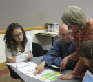
| Bryan works with educators at a COSEE-OS workshop |
|
In addition to being both a Maury Educator and a COSEE-OS Educator, Bryan Field is a veteran teacher of 12 years and science faculty member at Conant High School in Jaffrey, New Hampshire. He currently instructs classes in physics as well as biological and marine sciences. He has a scientific background- a master’s degree in oceanography - which he still draws strongly upon in his teaching practice today. Bryan has attended two COSEE-OS workshops:
Teaching Sciences by Ocean Inquiry at the University of Maine Darling Marine Center in summer 2008 and the
Educator-Scientist Concept Mapping Workshop at the University of New Hampshire (UNH) in March 2009.
Bryan was very familiar with concept mapping prior to participating in the UNH workshop, and currently uses it in his practice to organize curricula and lesson plans as well as help students review material and make connections. He has found that asking his students to work in groups to discuss the relationship between the many vocabulary terms helps them to really ‘understand’ as opposed to just ‘know’ the definitions.
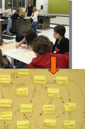
Bryan has found that the process of concept mapping is "extremely useful for the clarification of ideas." shows sophomores in his college preparatory biology class creating group concept maps based on vocabulary terms from a unit on genetics as a formative assessment and review assignment prior to their taking a multiple choice quiz.
| |
|
| Sophomores in Bryan’s college preparatory biology class create concept maps based on vocabulary terms from a unit on genetics | |
|
In preparation for UNH workshop, Bryan and the other educator participants were asked by COSEE-OS staff to assess specific Ocean Literacy / Climate Literacy Principles (OL/CL) in terms of the “relevancy level” to their own teaching situations, as well as their “comfort level” with the content behind the principles. For the CL Principle addressing the topic of carbon cycling and climate change, he stated that he likes for his students to “spend a lot of time working on the impact of humanity in the sea…covering climate change topics through exploration of biogeochemical cycling, carbon dioxide build-up, removal by algae, ocean acidification…” To help with these complex topics, Bryan enjoys encouraging his students to think of “systems ramifications” – how do all the parts of the ocean and climate systems link together at different spatial and temporal scales?
As a result of the UNH collaborative workshop, Bryan reports he will be able to show his students how to directly use the online Ocean Climate Interactive and the Concept Map Builder so they can build their own maps. Bryan plans to use the methods he learned at the COSEE-OS workshop to help his students organize information and see "the bigger story." He has shared his thoughts as to how he and his students react to and use concept mapping:
"I love the [COSEE-OS] tools and plan to use it with next year’s Oceanography classes. I tend not to be a linear thinker and find the standard outlining method does not work for me. On the other hand mapping seems to help me organize my thoughts and even think of connections and terms that wouldn't have occurred to me other wise. I know this is true for many of my students as well. Students tend to compartmentalize information, rather than make connections. With mapping they are forced to consider the relationships between, what are to them, otherwise disconnected terms."
Case Study 3: Gearing up for “Ocean First” Focus with Concept Mapping
Jennifer (Jenn) Bowdoin is a first-year teacher and science faculty member at Tabor Academy in Marion, Massachusetts – a four-year (9-12 grade) private boarding school that emphasizes marine sciences. Jenn teaches biology and marine biology courses including a semester-length elective class called “Advanced Marine Science – Field Research” comprised of juniors and seniors. Most of her students are interested in pursuing marine science or biology degrees.
| |
|
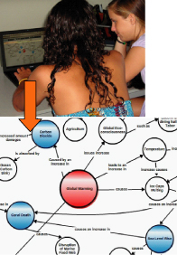
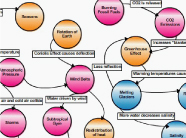
| Tabor Academy students create a concept map about global climate change to connect complex concepts learned throughout the semester |
|
Jenn, an alumna of the University of Maine with a Master’s degree in Marine Science and Marine Policy, learned of the COSEE-OS tools through interactions with members of the COSEE staff. She decided to use concept mapping in her classroom as an educational tool over the course of several days to introduce the complex topics of global warming and climate change. Jenn proposed that concept mapping would visually simplify the complex issues in a manner that would enable a high school student to understand them more intuitively than with traditional methods alone.
After she briefly outlined the concept process, the students began with a brainstorming activity in which they listed concept names on the class board. Next the students made decisions about how to “group” the multitude of concepts. For example, global warming became the central concept, followed by coral death, carbon dioxide, and sea level rise. They slowly began to develop a hierarchy of importance. The next day, she initiated the concept mapping exercise by providing a small example using the concepts generated in class. Jenn’s students then continued to elaborate and expand the map. Once all of the concepts were connected they discussed why the students had chosen to connect certain concepts, and then how to write meaningful connecting phrases. This type of candid and interesting open discussion led both teacher and students to question in a focused manner whether some “connections” were appropriate or valid. Jenn believes the concept map was and will be a “beneficial study tool” for her students. Also, the concept mapping technique allowed her to vary from the typical passive delivery of information (e.g., PowerPoint slides) resulting in some of the most interesting discussions the class had all semester!
The process of concept mapping allowed her (and the students) to draw connections between global climate change and the multitude of different marine ecosystems covered throughout the semester. Jenn states, “Students started to realize not only how all of the ecosystems -and what comprise them- are connected, but how they are influenced by changes in earth’s climate…leading to multiple ‘a-ha’ moments by my students.” In conclusion, Jenn found the COSEE-OS online concept mapping tools helpful and easy to use, and aided in creating an end product that proved to be a beneficial study tool. She plans to incorporate concept mapping and the webtools (OCI and CMB) into a brand new course beginning next fall called “Oceans First” – a comprehensive study of biology, chemistry, and physics using marine science as the focus.
Visit COSEE-Ocean Systems!