The COSEE Network has played an important and evolving role in linking the ocean sciences research community with educators and the public outreach sector. Online tools from the National COSEE Office and several Centers help in this process. While the tools differ (resources database, wizard, and interactive software) the underlying objective was the same: to provide an online mechanism to disseminate knowledge, create broader public awareness of the role of scientific discovery in society, and enhance educational opportunities.
COSEE Highlights
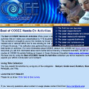
The Best of COSEE Hands-On Activities offers ocean scientists simple, engaging, and easily accessible hands-on activities to help make presentations to K-12 students, the public, or other non-science audiences more effective.
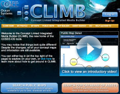
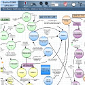
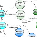
The Concept Map Builder is a web-based tool that allows users to create customized concept maps linked to videos, images, news, and resources. The resulting maps can be printed, downloaded as an image, share via email, exported as XML data or stored in our database for reuse or sharing with colleagues, students, peers, and the general public.
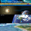
The Ocean Climate Interactive showcases fundamental science concepts which can be mapped within a big picture context. This flash-based application allows users to explore concepts and their relationships through a variety of assets - videos, images, news articles, and teaching resources - within a profile that gives breadth and depth to the learning experience.
This wiki-based document was designed and created collaboratively by the COSEE Excellence in Networking Tools Sub-group. The purpose of the guidebook is to help COSEE Network members become familiar with a wide variety of online tools so that they can choose the tools that best fit their needs.
Concept maps are designed to help teachers and their students understand the connections and relationships between climate and oceanography. For scientists, concept mapping helps them share their understanding of connections in the earth system. Public maps (created by our users and vetted by COSEE-OS scientists) are available for all to print, download as an image, share, export as XML data, or repurpose for educational use.