The World Resources Institute has created an interactive map detailing the world’s ocean dead zones. A dead zone is a region of eutrophication and/or hypoxia- zones where algae have bloomed (usually due to human-made reasons) and removed most of the dissolved oxygen from the water, making it impossible for other marine life to survive in that area. This map shows dots indicating dead zones across the globe and even includes click-able pop-ups to give more information about the area and possible causes for the deadzone.
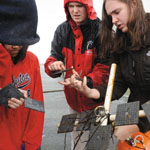
An environmental science teacher and students at Waterford High School in Waterford, CT are currently participating in a COSEE-TEK lead citizen science project to monitor water born pesticides and marine invertebrate communities in Niantic Bay area, Long Island Sound, and throughout the U.S.
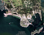
In conjunction with COSEE-TEK's "EVA & BOB Project", Project Oceanology has deployed three basic observation buoys (BOBs) in and around the mouth of the Thames River in the Eastern portion of Long Island Sound and they have been collecting water quality data including biological recruitment, organic contaminants, water temperature and light availability since then. Explore the map to access data and images from each location.